
G.H. McGill's Model Census 1861
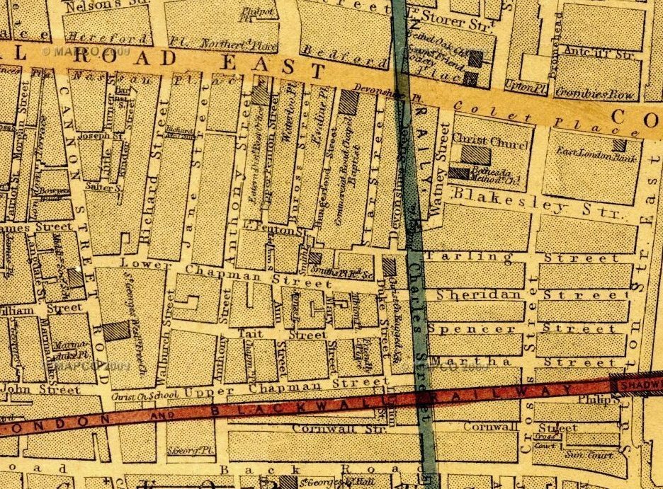
The Revd George Henry McGill produced the following statistics on 6 February 1861, for the parish area of Christ Church Watney Street (covering 43 acres). It can be compared with the Statistical Society's survey a generation earlier, in 1848, of the adjoining area to the west (broadly overlapping with what became the parish of St John the Evangelist-in-the-East).
| Number of: |
Places of worship |
Day Schools |
Sunday Schools |
Benevolent Societies |
|||||
| streets & courts |
52 |
Christ Church, C of E |
2,000 |
Christ Church, Boys |
350 |
Christ Church, Boys |
200 |
Penny Bank - depositors |
3,000 |
| houses |
1,888 |
School Chapel |
200 |
Christ Church, Girls |
200 |
Christ Church, Girls |
275 |
Dorcas Society |
70 |
| poor families |
c4,575 |
Beulah Chapel [General Baptist] |
600 |
Christ Church, Infants |
400 |
Christ Church, Bible Class |
25 |
Blanket & Rug Society |
100 |
| respectable families |
c512 |
Ragged Schools Church, C of E |
120 |
Middlesex, Boys |
120 |
Beulah Chapel [Gen Baptist] |
150 |
Christ Church Institute |
120 |
| persons |
c13,300 |
Trinity, Methodist [1] |
500 |
Middlesex, Girls |
115 |
Trinity Methodist [1] |
100 |
District Visitors |
21 |
| poor among them |
c11,000 |
Primitive Methodists [2] |
120 |
Adult School (Evening at Christ Church) |
60 |
Watney-street [2] |
30 |
Provident Society & Sick Club |
100 |
| Watney Street, ditto [2] |
50 |
School of Art [3] |
50 |
Ranters |
100 |
Mothers' Meeting |
100 |
||
| Workhouse, C of E |
500 |
Methodist Day School, Back-road [Cable Street] |
c150 |
East London Savings Bank, with a very large number of depositors. Deposits now invested, about |
£90,000 |
 [1] does this refer to the former Trinity Episcopal Chapel in Cannon Street Road which had become a Methodist chapel (though not with this name), or to somewhere else?
 Number of Houses |
Average Number of Families in Each House |
Number of Rooms in Each House |
Number of Poor Families in each Street |
Height |
Length |
Width |
Average Rental of Each Room per Week |
Remarks |
|||||
|
|
|
|
|
|
ft. |
in. |
ft. |
in. |
ft. |
in. |
s. |
d. |
|
|
6 |
1 |
2 |
16 |
7 |
6 |
10 |
0 |
9 |
4 |
1 |
6 |
Costermongers, labourers, slop-workers, &c |
|
|
44 |
4 |
4 |
176 |
7 |
3 |
9 |
4 |
8 |
7 |
1 |
9 |
Labourers and sailors |
|
|
48 |
3 |
4 |
144 |
6 |
11 |
9 |
10 |
8 |
9 |
1 |
10 |
Little tradesmen and lodging-houses |
|
|
47 |
3 |
4 to 6 |
141 |
7 |
2 |
10 |
0 |
9 |
7 |
2 |
0 |
Employed on the docks and on the river |
|
|
Browning's-court [Cannon Street Road] |
4 |
4 |
4 |
16 |
6 |
5 |
8 |
7 |
8 |
4 |
1 |
6 |
Very poor |
|
60 |
2 |
6 to 8 |
|
8 |
6 |
10 |
9 |
10 |
9 |
|
|
The principal street |
|
|
Catherine-street & court [later Anthony Street / court in Jane Street] |
68 |
3 |
4 to 6 |
150 |
9 |
0 |
7 |
6 |
8 |
6 |
2 |
0 |
Tradesmen and dock servants |
|
Chapel-street [later Tait Street] |
65 |
3 |
4 |
195 |
7 |
6 |
10 |
9 |
10 |
0 |
1 |
10 |
Small shops and labourers |
|
Charles-street [later Watney Street] |
44 |
4 |
4 to 6 |
176 |
7 |
8 |
10 |
0 |
9 |
5 |
1 |
10 |
Tradesmen, &c. |
| Church-road (west side) to Spencer-street [from Cable Street] |
62 |
2 |
4 |
124 |
8 |
0 |
9 |
7 |
8 |
10 |
1 |
10 |
Small shops, sailors, and dock labourers |
|
11 |
2 |
4 |
22 |
7 |
3 |
9 |
3 |
8 |
4 |
1 |
10 |
Lodging-houses and sailors |
|
|
89 |
3 |
4 to 6 |
267 |
7 |
4 |
9 |
10 |
8 |
0 |
1 |
9 |
Dock servants and small shops |
|
|
46 |
3 |
4 |
150 |
7 |
6 |
10 |
0 |
9 |
5 |
1 |
9 |
Labourers and lodging-houses |
|
|
Coburgh-court [near Charles Street] |
4 |
3 |
4 |
12 |
6 |
6 |
7 |
9 |
8 |
0 |
|
|
Very low |
|
Commercial-road (south side) from Cannon-street East to Sutton Street |
93 |
2 |
8 |
|
8 |
1 |
11 |
3 |
12 |
2 |
|
|
Respectable tradesmen, &c. |
|
61 |
3 |
4 to 6 |
183 |
8 |
6 |
10 |
0 |
9 |
0 |
1 |
9 |
Very poor |
|
|
Cross-street (part) |
29 |
2 |
4 |
58 |
6 |
1 |
9 |
9 |
8 |
5 |
1 |
9 |
Small shops |
|
Dean-street [later Deancross Street] |
24 |
2 |
6 |
48 |
7 |
5 |
8 |
6 |
7 |
7 |
3 |
6 |
Clerks and persons employed in city |
|
60 |
4 |
4 |
240 |
8 |
0 |
8 |
4 |
8 |
2 |
1 |
9 |
In this street and Star-street there are living in 123 houses about 1,500 persons, including 300 children, many without shoes or stockings |
|
|
38 |
4 |
4 |
140 |
7 |
3 |
9 |
0 |
8 |
7 |
1 |
9 |
Very low and poor |
|
|
29 |
3 |
5 to 6 |
87 |
8 |
2 |
10 |
0 |
9 |
6 |
2 |
0 |
Sailors and dock labourers |
|
|
13 |
2 |
4 |
26 |
7 |
6 |
9 |
7 |
7 |
10 |
1 |
10 |
Ditto ditto |
|
|
5 |
1 |
2 |
10 |
7 |
2 |
8 |
11 |
8 |
8 |
1 |
3 |
Low |
|
|
41 |
4 |
4 |
164 |
7 |
2 |
9 |
1 |
8 |
9 |
1 |
9 |
Very poor |
|
|
John-street, Lower [later Blakesley St] |
33 |
2 |
6 |
|
7 |
8 |
8 |
7 |
7 |
9 |
3 |
6 |
Clerks and middle class |
|
John-street, Upper [later Blakesley St] |
25 |
2 |
6 |
7 |
6 |
8 |
7 |
7 |
0 |
3 |
6 |
|
|
|
Jones-row [Mary Street] |
6 |
2 |
2 |
12 |
8 |
0 |
9 |
10 |
9 |
5 |
1 |
8 |
Very poor and miserable |
|
38 |
2 |
4 |
76 |
7 |
3 |
9 |
9 |
8 |
6 |
1 |
9 |
The worst street in the district morally |
|
|
46 |
2 |
4 |
92 |
7 |
0 |
10 |
0 |
9 |
3 |
1 |
9 |
Very low and immoral |
|
|
8 |
4 |
4 |
32 |
7 |
6 |
9 |
11 |
8 |
7 |
1 |
9 |
Labourers, sailors, and families |
|
|
29 |
4 |
4 to 6 |
116 |
7 |
8 |
9 |
2 |
8 |
3 |
1 |
9 |
Labourers |
|
|
30 |
4 |
4 |
120 |
7 |
3 |
8 |
4 |
8 |
2 |
1 |
10 |
Sailors and warehousemen |
|
|
New-road (north side) |
79 |
3 |
4 to 6 |
79 |
8 |
1 |
10 |
8 |
9 |
5 |
2 |
3 |
Tradesmen and sailors |
|
71 |
3 |
4 to 6 |
142 |
8 |
6 |
10 |
0 |
9 |
10 |
2 |
6 |
Warehousemen, &c. |
|
|
St.
George's-place [part of Cable Street] |
20 |
2 |
8 |
|
8 |
10 |
8 |
7 |
7 |
4 |
3 |
0 |
Lodging-houses |
|
10 |
3 |
4 |
30 |
7 |
10 |
10 |
0 |
8 |
11 |
1 |
9 |
Very low and poor |
|
|
Smith's-place [later Agra Place] |
10 |
3 |
4 |
30 |
6 |
8 |
9 |
8 |
8 |
10 |
1 |
6 |
Very poor |
|
Short-street [location not identified] |
3 |
2 |
4 |
6 |
8 |
0 |
10 |
0 |
9 |
10 |
1 |
10 |
Labourers in gas-works |
|
Spencer-street (north side) |
81 |
3 |
4 |
243 |
7 |
2 |
8 |
11 |
8 |
4 |
1 |
10 |
Sailors, labourers, and sugar refiners |
|
63 |
4 |
4 |
252 |
8 |
5 |
9 |
6 |
9 |
6 |
1 |
9 |
Very low and miserable |
|
|
29 |
2 |
4 to 6 |
58 |
7 |
9 |
8 |
9 |
7 |
11 |
4 |
0 |
A few respectable inhabitants and lodgers |
|
|
89 |
3 |
4 |
267 |
7 |
10 |
9 |
5 |
9 |
5 |
1 |
10 |
Labourers, sailors, and their families |
|
|
Union-street and passage [aka Little Union Street - off Lower Chapman Street] |
24 |
3 |
4 |
72 |
8 |
0 |
10 |
2 |
9 |
3 |
1 |
8 |
Hawkers, fishmongers, &c. |
|
21 |
3 |
6 |
63 |
8 |
6 |
9 |
10 |
9 |
4 |
1 |
10 |
Clerks and respectable inhabitants |
|
|
Virginia-court [location not identified] |
3 |
3 |
4 |
12 |
6 |
7 |
9 |
4 |
8 |
5 |
1 |
6 |
Very poor |
|
42 |
3 |
4 to 6 |
126 |
8 |
1 |
9 |
9 |
9 |
5 |
2 |
0 |
Persons engaged in slop work |
|
|
45 |
2 |
6 |
|
8 |
6 |
14 |
0 |
10 |
0 |
|
|
Respectable inhabitants |
|
|
White's-gardens [formerly Star Place] |
6 |
2 |
4 |
12 |
8 |
2 |
9 |
6 |
9 |
6 |
1 |
9 |
Low and poor |
|
York-place [Lower Chapman Street] |
6 |
3 |
4 |
|
7 |
4 |
9 |
11 |
8 |
6 |
1 |
9 |
Poor but decent labourers |
|
Totals |
1818 |
|
|
4392 |
|
|
|
|
|
|
|
|
|
Back to Christ Church Watney Street | Back to 1848 Statistical Survey | Back to St John the Evangelist-in-the-East